5th International Remote Sensing and Space Science Workshop,
1st Archaeological conference
“Hidden Landscape Under Blue Sky”
6-7th June 2011, Ulaanbaatar, Mongolia
In the last 4 years NUM-ITC-UNESCO Remote Sensing/GIS Laboratory, The National University of Mongolia, Ulaanbaatar, Mongolia organized workshops of Astronomy and Remote Sensing, this year, thanks to meet to Dr Tsolmon Renchin and Dr Anna Maria Marras it is added a new topic : Landscape archaeology:
From the Hidden Landscape to the Blue Sky of Mongolia is a workshop on application of Remote Sensing and GIS for the study of sky through the landscape.
Space and time are creating the human and natural landscape. For this reason the interest in landscape transcends many traditional academic divisions and disciplines. The landscape archaeology syncretize several fields of research in order to multitemporal reconstruction layer by layer of human and natural shape.
The applications of remote sensing and GIS system give the possibility to better investigate and analyze the potentiality of landscape, to discover its past and to plan its future development. The first aim of this workshop is to involve several know- how of technology and humanity for the study of the Mongolian Landscape. The potentiality of the Mongolian cultural landscape is huge and the manifold shapes of this great land are also its great resource.
The local progress and the cultural heritage documentation have to go together step by step. Remote sensing technology and GIS are the scientific tools to discover, manage and disseminate the landscape archaeological heritage data, in order to preserve and to disseminate multidisciplinary knowledge of landscape.
The second aim is the remote sensing application in the promotion of the astronomical study with accent in Mongolia. Space science provides many hidden information about our galaxy, human and our planets inter-linkage with it.
The workshop is open to researchers, scientists,
students, government and non government officials, academics, and general
private and public who has interest to deliver their work, intent in
application of geoinformation for fields from the archeology to the astronomy,
including vast layer of land, atmosphere and processes that occur in. It
welcomes all to share knowledge and skills, to learn from each other and come
to the common consensus in future progress.
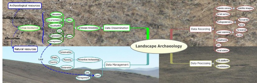
Sketch of Landscape Archaeology Research
